Major Snowstorm set to impact Denver and Northeast Colorado
A major snowstorm is set to hit Denver from Monday evening into Tuesday. The biggest difference in this snowstorm compared to the ones we have already experienced this season is that this snowstorm will hit hard and fast rather than being a longer duration event.
What I mean by this is that it won't start snowing heavily until after dark on Monday and by the time we wake on Tuesday, there very well could be a half a foot of snow on the ground. Or more. I'm thinking more.
So, the shock value will be big with this one.
Details:
Monday will be a rather dry day. That is, up until the evening commute. Snowfall will begin across Denver after 3PM. Snowfall rates will be low at first but will quickly begin to increase as we head from 7-10PM. HEAVY snow will fall throughout the entire night into Tuesday morning. Travel is expected to be EXTREMELY difficult Tuesday morning if not impossible.
Winds will also be gusty throughout this snow event. We're looking at relatively light winds about 10-15mph mostly, but there could be times that we see winds increase to over 20+ to 30+ mph. This could lead to blizzard conditions...blizzard highlights may become necessary on the eastern Plains of Colorado. Possibly even in and around Denver.
 |
| Snow animation showing heavy snow through Monday night into Tuesday |
Snow will continue Tuesday morning and last through about noontime. Total snow looks to be between 8-14" for Denver with 10" to 2 feet possible near Boulder and in the Foothills.
There are a couple of variables we need to look at and think about in regards to this storm.
When looking at all of the model's snowfall outputs - by Tuesday, there is once common theme 1) there's a sharp cut-off line on the south side of the storm where over the distance of about 30 miles or so, you could see 4" of snow or 14" of snow depending on where you live in town. Some models have that line sitting right over the Denver metro.
 |
| NWS Boulder's Snowfall Prediction |
There are some variables that could lead to there being more snow in and around Denver. 1) this storm could come in stronger than original thinking. NOTE: The models have been trending slightly stronger over the last few runs. 2) the storm could come in further south, leading to the southern cut off line moving further south of the city. That would likely ensure Denver with double-digit snow totals. 3) this storm may move slower than current thinking. If it were to last longer that would mean more snow. 4) finally, there could be a stronger upslope wind event on Tuesday that lasts longer into the day which would also lead to higher snowfall totals.
As you can see, there are several ways that Denver could get more snow than forecast. With that said, there is also the possibility of Denver ending up with the low-end amount. Even with the low-end amount, which is about 6", this will still be an impactful snow event.
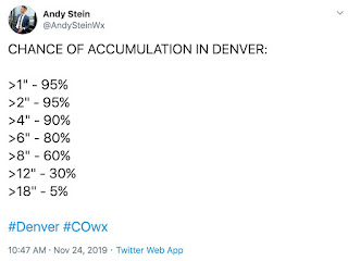 |
| Chance of snow accumulations in Denver |
An impressive fact about this storm is that there will be a lot of moisture with it. Some models are suggesting that Denver could get over 1" of liquid precipitation from this storm. That's impressive for November standards. Or really any time of the year in Denver.
A good rule of thumb when talking snow totals is to look at that liquid precipitation because a general rule in the meteorological community is to use a 10:1 ratio when forecasting snow. That means that one inch of liquid precipitation equals 10 inches of snow or that 10 inches of snow can melt down to one inch of liquid. That ratio varies depending on temperatures. The warmer the surface temperature, the lower the ratio (think 5:1). The inverse to that is lower temperatures and higher ratios (think 15:1 and sometimes greater).
We're expecting cold temperatures to accompany this storm so our ratios may end up around 15:1 or 18:1. That will also have an impact on snow totals coming up.
IMPACTS
This storm WILL have wide-reaching impacts all around northeastern Colorado. Travel will be extremely difficult on Tuesday morning if not impossible. You should prepare to not travel Monday night into Tuesday at all because this storm will come in fast and snow will begin to stick quickly. Airport delays are likely Monday night and Tuesday. Road closures are possible on major thoroughfares.
Please have an emergency snow kit ready in your vehicle is you must travel. This includes; snacks, water, blankets, extra gas, a flashlight, first aid kit, boots, gloves, cell phone charger and batteries. If you have chains, be sure to have those handy. A snow scraper and jumper cables will be good to remember as well.
Snow will end by Tuesday afternoon. Temperatures will remain cold and ski will be mostly cloudy. Tuesday's evening commute will likely be very icy with snow-packed roads. Snowplows will likely be out all night Tuesday into Wednesday morning clearing roads but Wednesday mornings commute may be very slick as well. Prepare for winter driving conditions through Wednesday morning. High temperatures on Wednesday will likely stay near freezing with partly cloudy skies. Our powerful Colorado sunshine will help some but not all roads on Wednesday. This may lead to slippery conditions lasting on the roads through Thursday.
Stay up to date with current weather hazards from Andy's Twitter and the NWS Boulder twitter. Current travel conditions, road closures and traction laws can be found on the Colorado DOT twitter.
Stay safe!
~Snow or shine
I'm Andy Stein

Comments
Post a Comment