DENVER WEATHER: Light snow continues, Cold sets in, More snow on the way
HOW MUCH SNOW FELL?
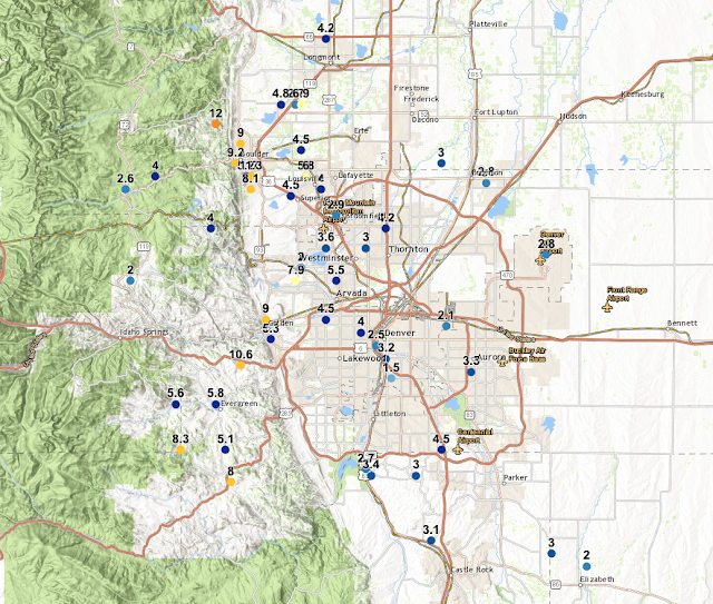
Monday was a very snowy day across the region with mostly light snow falling in most areas. That led to varying snowfall totals. Areas in Denver saw anywhere from 2-5 inches of snow. Areas towards Boulder and Genesee and other communities in the Foothills, saw anywhere between 5-13 inches of snow!
 |
| Snowfall through Tuesday morning |
We will have more snow through the day on Tuesday but it shouldn't amount to much more than an additional 1-3 inches of snow. Skies will begin to clear Tuesday night. This wasn't a blockbuster storm but it was definitely a shock to the system.
TEMPERATURES
We woke up this Tuesday morning to a cold 7ºF. 35 hours before that cold temperature reading, we were basking in 74ºF record heat. So, in that 35 hour period in between those readings, Denver experienced a 67ºF temperature drop. That unofficially puts us in the number 14 spot for the largest 2-day temperature drop in Denver's history. If we look at the temperatures change within 24 hours of that 74ºF reading, we saw a 55ºF temperature drop which lands us tied for 12th for the largest 1-day temperature drops.So, a pretty impressive blast of cold air but not our biggest.
 |
| Wake Up Temperatures on Wednesday (2/5/2020) |
Temperatures, as we head to Tuesday night, will be some of the coldest air we have seen all season. We are expected to drop below zero for the first time since November 27, 2019. That's when we got to -2ºF. Tonight, we could fall even colder than that. More importantly, the wind chill values, or the "feels-like" temperatures, will be in the teens below zero. It will feel like -10º to -20º at times, depending on your location.
So, it's going to be frigid out. Wednesday will be sunnier and warmer. Highs will be in the low to mid-30s and that will help alleviate some snow from the roads.
MORE SNOW ON THE WAY
As we continue to chip away the days in February, we will continue to have chances of snow. This is quite the pattern shift compared to what we endured in December and January. So, going forward, just be ready for it to actually feel like winter and be ready to see snowflakes flying more frequently than in recent memory.
February 6-7 -- After Tuesday's light snow, we have a chance of snow returning to the region for Thursday night and into Friday. An additional 1-3 inches of snow may fall by Friday night.
February 9-11 -- Then, the longer-range models are hinting at another round of snow between Sunday and Tuesday of next week. That could also provide additional minor accumulation.
February 12-15 -- Another sign of some light now is showing up in this period. Minor accumulation could occur but as of now, this does not look like a very impactful storm but it is far out and we will have to wait on the details to clear themselves.
February 15-16 -- It's hard to decipher the differences in these systems at this point but another round of snowfall is possible during this time frame. To be honest, anything passed this weekend will likely change, but the signals of snow are showing that there is a different weather pattern impacting us whereas, through December and January, there were barely any signals of snow.
WEEKLY OUTLOOKS
The Climate Prediction Center (CPC) is showing colder than normal temperatures expected between not and February 17th. That means, that we have a shot at seeing below-average temperatures continuing for the 2 weeks.
 |
| National Temperature Outlook between February 11-17. |
The CPC is also showing above-normal chances of precipitation during the next two weeks.
 |
| National Precipitation Outlook between February 11-17. |
With colder temperatures and increased moisture expected, we can translate that to a snowier than normal period is expected over the next couple of weeks.
We will see how all of this plays out.
WHAT ABOUT THE MOUNTAINS?
Oh yes, the mountains will be getting WALLOPED with snow.February 5-7 -- A strong signal of snow is being seen during this time. The north-central mountains will benefit the most with 6-18 inches of snow expected. The southern mountains can expect between 3-12 inches of snow.
February 9-11 -- Another round of snow is expected during this period. This time, the southern mountains will receive more snow. Between 5-15 inches of snow is possible for them during this period. For the north-central mountains, 4-10 inches of snow can be expected. This forecast could change as we clear up some of the data.
February 13-20 -- More signals of intermittent snow can be expected for this period. This far out, it's hard to distinguish storms but there are signs of consistent light to moderate snow totals for mountain locations.
This will all add to our above-average snowpack but will also lead to an increased risk for avalanche danger for a prolonged period of time.
STAY READY
Keep in mind, there will be winter driving conditions quite a few days out of the next couple of weeks. Especially if you are finding yourself in the mountains. Keep your winter driving kit stocked.
Stay tuned for more!
Rain or Shine
I'm Andy


Comments
Post a Comment