Unpleasant Friday Forecast
We made it to Friday - Friyay!
Today is going to feature a lot. Colder, cloudier, foggier, rain, snow, wintry mix. It's all possible somewhere.
 |
| FOG at DIA Friday morning. Fog was causing delays to inbound and outbound flights |
Let's jump straight in. Visible satellite this morning is showing lots of clouds and a semi-obvious trough rolling across the Four Corners. This is our storm today and into the weekend. Check it out!
Overall, it'll be a relatively cloudy day. The Plains may clear up a bit, especially from the fog which should burn off by midday but clouds will be persistent at times during the entire day. There's already a decent amount of precipitation falling in Western Colorado this morning and more of that is to come - and more of that will be spreading east.
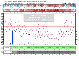
Today is also going to feature colder temps (which will be a trend through Monday!) Highs will struggle to get to 40, especially with this cloud cover around.
So what's the sitch?
This trough that's moving across the area is doing pretty good in the weather department. It's going to strengthen on the Lee side of the Rockies and develop into a big winter storm for the Central and High Plains today through Sunday and create a large severe weather risk across the Central Plains and Southeast between today and tomorrow. (See below)
 |
| Severe storms Friday PM |
 |
| A Winter Storm Friday through Sunday |
What this shows is that precip (I'll generalize it as that because it could start as rain and then change to snow) will begin around the evening commute. We'll say between 4-6PM. If you're going to the 9NEWS Parade of Lights tonight, there may be some light snow around just to make it feel more festive out!
Snow won't last forever and it'll be light stuff. Not looking at significant accumulation but a dusting to an inch could fall over the metro.
The western Colorado mountains are going to see 5-10" of snow through the weekend! Good stuff for them. Meanwhile the Eastern Plains will be relative dry (snow-wise) - not looking at huge accumulations there with the exception of maybe the 4-5 counties in far northeast Colorado. While snow may not make a huge presence on the Eastern Plains - rain will be quite heavy at times. Could even see some thunder. Amounts are looking to be around .10"-.50".
The storm that we've been watching for Sunday to Monday looks like a dud. It'll bring the mountains another chance of snow but it's not looking to bring Denver much of anything except for some flurries and maybe a snow shower - overall accumulations aren't looking the greatest.
Lastly, temps. Bundle up y'all. It's going to be chilly for a while.
We'll chat more if anything changes!
~Rain or Shine
I'm Andy Stein
Snow won't last forever and it'll be light stuff. Not looking at significant accumulation but a dusting to an inch could fall over the metro.
 |
| SNOW THROUGH TUESDAY |
The storm that we've been watching for Sunday to Monday looks like a dud. It'll bring the mountains another chance of snow but it's not looking to bring Denver much of anything except for some flurries and maybe a snow shower - overall accumulations aren't looking the greatest.
Lastly, temps. Bundle up y'all. It's going to be chilly for a while.

We'll chat more if anything changes!
~Rain or Shine
I'm Andy Stein

Comments
Post a Comment