WINTRY MESS Impacts East Coast
Well well well. What an active map we have here.
We have our first rather large-scale wintry event about to unfold! Now, you may have seen some pictures/videos of it snowing in Galveston, TX (GALVESTON SNOW) or Shreveport, LA - pretty crazy right? That's the earliest it has ever snowed in those two cities.
That's significant in the sense that this recent cold blast is setting the stage for the wintry mess were about to see unfold out east.
Let's dive in!
Also of note in the water vapor imagery - tons of moisture is surging in from the G.O.M (Gulf of Mexico). Moisture and cold air spells wintry weather!
Now - for further analysis, here's the upper level vorticity (or the available spin or rotation available in the atmosphere - more vorticity = more energy to work with).
Note: the red arrow denoting where this energy is going to go.
Now - the tricky part is that this storm is going to have multiple facets to it. Flooding rains, dangerous ice, heavy snow. What precipitation type you receive at your home is going to be completely contingent on temperature but it's not the temperature that you feel outside your door. It's the temperature about 5, 10, 20 thousand feet up!
The orange, denoting where warm air is located within the depths of the atmosphere, is called the "warm nose". This is going to be a huge factor for some who see wintry precipitation. It'll be the distinguishing factor between snow and ice, a little ice or a lot of ice, some ice and some sleet and so on. Basically - wintry precipitation is extremely hard to nail down because if the temperatures vary even a little bit - it'll mean a big difference in what type and how much precipitation you get.
FORECAST MODELS:
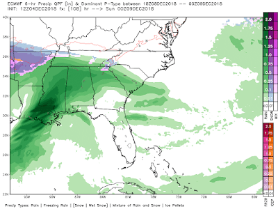
So what does this mean for precip amounts? That's where it's tricky.
You can see that Freezing rain is the most likely contributor to us seeing a nasty ice accumulation. Could be in the range of a tenth of an inch to 2/10ths of an inch. Doesn't sound like much - but that's all it takes to cause issues. Also, sleet could accumulate up to 1-2" in some spots above 2500'.
Rain will also be a big deal. Watch out for some flooding to occur in Northern Georgia, the Upstate of SC and the Piedmont and Western NC.
Just take it easy if you HAVE to travel tonight into Thursday afternoon.
MOVING ON: Phew, that was long winded. Sorry - but here's more :)
The northeast is also expecting a MESS of weather for the rest of the week. We've seen some impressive lake-effect snows here recently and that could again be the case for some AFTER the main event.
Check it what's coming though:
What this models (again the European) shows is that precip won't start for many until Thursday morning but Thursday is going to be an increasingly nasty day start from the south and moving north. This storm is expected to strengthen as well. What this means is precip rates are going to be heavier. No matter which type of precip you get. Totals accumulations here are as follows:
Notice that this is going to be mainly a snow event for the northeast. There may be some sleet or ice to begin but as this systems deepens (or strengthens), snow will be the primary concern and there could be quite a bit for some folks. Winter weather alerts are up for much of the northeast.
Take it easy. Bundle up and be prepared for a pretty decent storm!
Thanks for reading this extremely long winded blog! :)
Thanks for reading this extremely long winded blog! :)
~Rain or Shine
I'm Andy Stein
I'm Andy Stein


Comments
Post a Comment