Denver Snow Update
It's probably just me, but I'm excited about the upcoming snow! What I haven't been excited about is how difficult it has been to forecast this event.
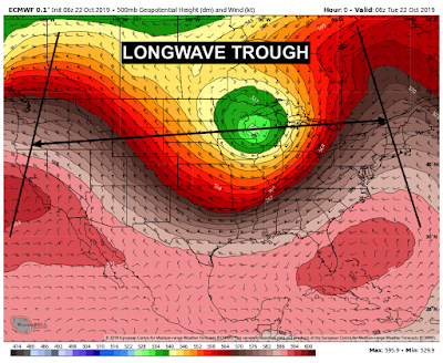
The Colorado Mountains have been benefitting from a favorable snow pattern since the weekend. That's because a long-wave trough has been slowly progressing from West to East over the last few days. Essentially what that means is that we've had winds coming from the WNW which favors the high terrain with orographic lifting (think topography and our numerous 14,000-foot mountains we have) and that produces pretty consistent snow for them.
A longwave trough is a big stream of energy and moisture, think about a large scale current like the Gulf Stream but instead of in water, it is a stream in the atmosphere. Normally with troughs of any kind, you find cooler temperatures and that's what we've been feeling in Denver recently, breezy and cooler weather.
Now, a longwave trough is a large scale weather pattern. There's a subcategory to these - shortwave troughs.
Shortwave troughs are chunks of energy and moisture that break off of the main flow of the longwave trough. Those shortwaves play a crucial role in forecasting because they can sometimes move more erratically and depending on their movement, whether it be to the south, the east or any combination of direction, will largely have different impacts depending on your location and the local climates and terrain near you.
SO WHAT DOES THIS HAVE TO DO WITH OUR WEATHER?
Glad you asked! I mentioned there has been a longwave trough impacting the western 2/3rds of the country. Well, a shortwave trough is expected to break off of that main flow and impact Colorado.
These shortwaves, depending on their strength and trajectory, can bring some very hefty snow totals to Colorado's Foothills and Plains. This shortwave is beginning to break off near Wyoming and is looking to travel almost due south through the remainder of the week. This bodes well for an upslope snow event for almost all of the Foothills in Colorado. Because of this, Winter Storm Watches have already been issued for some areas.
Up to 12" of snow could fall in the Foothills and the Palmer Divide (an area of higher elevation in between Denver and Colorado Springs). This will begin on Wednesday afternoon in the High Terrain and slowly move into lower elevations. Now, as of this moment, we have winter alerts issued in the highlighted areas above but snow is expected almost everywhere in the state. What the NWS is waiting for is to see how this storm develops, that goes a long way for accurate forecasting.
Denver is anticipated to get between 1-3" of snow but that could go up between now and when the first flakes fly.
Something of note, the shortwave trough is going to be amplified by the jet stream which will provide more energy and more moisture for the areas. What we have to watch for is the timing of all of these dynamics. When does the shortwave develop and how fast does it develop? When does the cold front move through? When does moisture move in? When does the jet stream amplify all of these?
Those are questions that have yet to be answered but we have a good idea on the timing, for the most part.
First, the cold front is likely to move through the area during the later afternoon hours on Wednesday. Then the energy from the shortwave and the jet stream will move overhead later on Wednesday evening. This will create widespread snow for the region possibly in time for the Wednesday Evening Commute. Plan for delayed and tricky travel.
Snow will continue through the night and into Thursday morning and the shortwave continues its trek to the south. Thursday morning looks cold and rather snowy so make sure to give plenty of time to get ready on Thursday. By Thursday afternoon, our winds shifts and we start to clear out and warm up. Only in the 30s and low 40s though.
Again, there are a few unknowns here. If the dynamics come together perfectly, we could see several more inches of snow in Denver but based on the current modeling, the Foothills, Palmer Divide and areas in Southern Colorado will see the most snow from this system.
Notice where the brighter pinks are located. Along the Foothills, the Palmer Divide and areas around Pueblo. Denver, in this particular modeling, will see snow totals ranging from 3-6". This is absolutely possible but again, we have to see how all of the ingredients come together.
For now, yes, it's going to snow.
DETAILS
Snow beginning Wednesday afternoon/evening, possibly in time for impacts on the evening commute. Tough Thursday morning commute with a cold day expected Thursday. Clearing by Thursday afternoon.
1-5" for Denver.
Boulder could see 5-10".
Areas south of Denver could see up to a foot of snow.
The further east you live, the less impacted you'll be by this particular storm.
Let's see what happens!
Oh, and by the way, it looks like another storm is possible Sunday to next Wednesday with some bitter cold temps and more snow possible. More details on that later.
~Rain or shine,
I'm Andy Stein
The Colorado Mountains have been benefitting from a favorable snow pattern since the weekend. That's because a long-wave trough has been slowly progressing from West to East over the last few days. Essentially what that means is that we've had winds coming from the WNW which favors the high terrain with orographic lifting (think topography and our numerous 14,000-foot mountains we have) and that produces pretty consistent snow for them.
A longwave trough is a big stream of energy and moisture, think about a large scale current like the Gulf Stream but instead of in water, it is a stream in the atmosphere. Normally with troughs of any kind, you find cooler temperatures and that's what we've been feeling in Denver recently, breezy and cooler weather.
 |
| LONGWAVE Trough currently over the US (as of midday Tuesday) |
Shortwave troughs are chunks of energy and moisture that break off of the main flow of the longwave trough. Those shortwaves play a crucial role in forecasting because they can sometimes move more erratically and depending on their movement, whether it be to the south, the east or any combination of direction, will largely have different impacts depending on your location and the local climates and terrain near you.
SO WHAT DOES THIS HAVE TO DO WITH OUR WEATHER?
Glad you asked! I mentioned there has been a longwave trough impacting the western 2/3rds of the country. Well, a shortwave trough is expected to break off of that main flow and impact Colorado.
 |
| SHORTWAVE trough expected over the Four Corners Thursday |
 |
| Winter Storm Watches issued through Thursday |
Denver is anticipated to get between 1-3" of snow but that could go up between now and when the first flakes fly.
Something of note, the shortwave trough is going to be amplified by the jet stream which will provide more energy and more moisture for the areas. What we have to watch for is the timing of all of these dynamics. When does the shortwave develop and how fast does it develop? When does the cold front move through? When does moisture move in? When does the jet stream amplify all of these?
Those are questions that have yet to be answered but we have a good idea on the timing, for the most part.
First, the cold front is likely to move through the area during the later afternoon hours on Wednesday. Then the energy from the shortwave and the jet stream will move overhead later on Wednesday evening. This will create widespread snow for the region possibly in time for the Wednesday Evening Commute. Plan for delayed and tricky travel.
Snow will continue through the night and into Thursday morning and the shortwave continues its trek to the south. Thursday morning looks cold and rather snowy so make sure to give plenty of time to get ready on Thursday. By Thursday afternoon, our winds shifts and we start to clear out and warm up. Only in the 30s and low 40s though.
Again, there are a few unknowns here. If the dynamics come together perfectly, we could see several more inches of snow in Denver but based on the current modeling, the Foothills, Palmer Divide and areas in Southern Colorado will see the most snow from this system.
 |
| ECMWF Snow Totals through Friday. |
For now, yes, it's going to snow.
DETAILS
Snow beginning Wednesday afternoon/evening, possibly in time for impacts on the evening commute. Tough Thursday morning commute with a cold day expected Thursday. Clearing by Thursday afternoon.
1-5" for Denver.
Boulder could see 5-10".
Areas south of Denver could see up to a foot of snow.
The further east you live, the less impacted you'll be by this particular storm.
Let's see what happens!
Oh, and by the way, it looks like another storm is possible Sunday to next Wednesday with some bitter cold temps and more snow possible. More details on that later.
~Rain or shine,
I'm Andy Stein


Comments
Post a Comment