Let's Talk Tropics
The tropics are acting up again! It's not out of the norm for this to happen. After all, we are still in hurricane season.
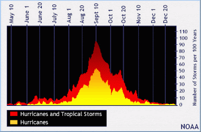
What you can gather from the iamge above is tha fact that we are very close to October 20 and that's when we typically see a secondary 'peak' of hurricane season. In years past, we've seen an increase in activity around this time. This year in no different.
With this trajectory over the southeast US, expected some heavy rain and winds to occur something between Friday and Sunday depending on your location. If/when this thing forms into an actual storm, it will have the typical threats with it. Heavy rain, gusty winds and storm surge.
 |
| Hurricane Season activity |
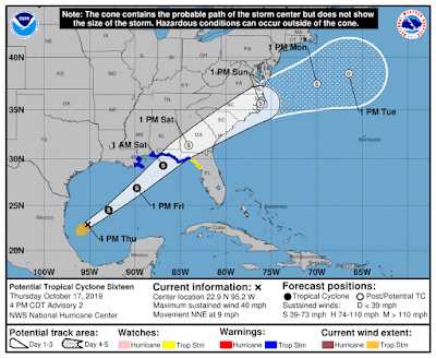
So, what are we watching? We're watching what the NHC (National Hurricane Center) is calling "potential" tropical cyclone sixteen. A Potential tropical cyclone is defined as "a disturbance that is not yet a tropical cyclone, but which poses the threat of bringing tropical storm or hurricane conditions to land areas within 48 hours" (Defined by the NHC).
So there it is! PTC 16. If it were to be named (which, they'll probably pull the trigger), it would be named Nestor. PTC 16 has formed so far west that the last time we saw a tropical cyclone form this far west in the Gulf of Mexico, we have to go back to 1985!
PTC 16 is likely to be picked up by the Sub-tropical just and move northeast rather quickly.
 |
| PTC 16 forecast path. |
WIND
Wind will be a minor concern. Those along the immediate coast could expected the bulk of the winds from this system.
 |
| Max wind gusts expected through Sunday. |
This is a look at the maximum wind gusts expected through the weekend. Those in the Florida Panhandle, southeast Alabama and Southern Georgia will see the possibility of widespread tropical storm forced wind gusts. Those along the Georgia, South Carolina and North Carolina coast could also expect similar conditions. This is enough to bring smaller branches down and create some rough driving conditions in rain sqaulls.
RAIN
Rain is always an issue and even with *just* a tropical storm, we have to be aware that this system is carrying A LOT of moisture with it. It's never *just* a tropical storm (cue T.S> Imelda that ravaged coastal texas with FEET of rain). Now, I'm not expected feet of rain but some very heavy rain is possible.
 |
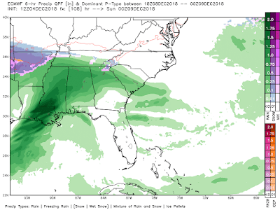
| Rain totals through Sunday |
This is a look at the rain totals through Sunday. Notice how there's a widespread swatch of 1-4" of rain expected from Coastal Mississippi to North Carolina. This is actually some good news as there's a pretty harsh drought happening currently. Of course, we don't want all of this to fall in a short amount of time because that would cause flooding BUT this tropical system is hitting and area of the country that needs some tropical rains. Pay attention to flash flood watches - they're likely.
STORM SURGE
Storm surge is always a concern with a tropical system coming onshore and this is no different. Storm surge and coastal flooding will be possible from the Louisiana coast to Tampa Bay in Florida.
 |
| Storm surge expected |
The expected storm surge will be 3-5 feet in areas of pink above. This is very high for areas of Florida that are at or below sea level. Areas from the Louisiana coast to the Western Florida Panhandle will likely see some coastal flooding with a surge of 1-3'. Prepare what you need.
TROPICAL STORM ALERTS are already in place.
 |
| Tropical Storm Alerts |
Notice how the tropical storm alerts extend from Louisiana to Florida and inland to the Alabama and Georgia borders. This will be a relatively quick-moving system but one that will impact you a good deal over the next few days.
We *could* see tropical storm alerts posted for the Carolinas as well but we'll have to wait and see.
Stay prepared! And stay in the know!
Rain or Shine
I'm Andy Stein


Comments
Post a Comment