Wednesday June19 - Weather Update
Yesterday was a pretty wet day for a lot of people in Colorado. It rained at varying intensities all across the state. DIA picked up just under an inch of rain in 10 minutes!! and had winds gusts to 54 mph!
With that added burst of rain, we are officially more wet than ALL of last year. Check out my last blog for the numbers I'm referencing.
As we continue on, an isolated rain shower can be expected today but it won't be intense of damaging winds or hail - can't rule that out completely right along the CO/KS border but most areas will be calm.
Temps have heated up finally. We made it to at least 80º - it seems like it's been awhile. Thursday will be similar to today with highs in the 80s and then a slight chance of afternoon storms but it will remain largely dry for everyone.
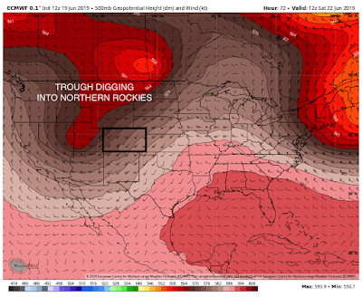
What I'm watching is a big trough digging into the Western US. This is our next storm system that will bring a lot of unsettled weather to the area this weekend.
DETAILS:
Ok so, here's the deal - this trough that is moving onshore is anomalously strong for this time of the year. It's bringing in some cold air aloft and some moisture too. What that means for us down in Denver is that temperatures are going to cool and rain is back in the forecast.
Like I mentioned before, Thursday will be a nice day out. We have our typical chance for an isolated shower but by large, we will be dry. Highs will be in the mid-80s. By Thursday night we will watch our cold front approach. This will bring in SWerly winds for the evening.
By Friday, a cold front moves through bringing rain and cooler air to the region. I'm not anticipating a lot of severe weather with this FROPA (frontal passage, cool word, huh?) but the possibility is there for a storm to turn severe. Highs on Friday are looking to drop by 15º or so. We're looking at 70º highs again through Sunday.
Saturday will be interesting too. A seconding trough will bring a reinforcing shot of cool air in and keep cloud cover and rain (and snow) showers through the state. Again, not looking severe but can't rule out and isolate strong storm.
Sunday will begin the drying process but it'll take the day for us to really notice anything. Just clearing skies by the evening hopefully which leaves the rest of the day under a threat of showers.
The rain that falls will be heavy. We could be looking at rainfall totals across the northern half of the state to be in the 1-2" range. Meanwhile, the southern half of the state will see between 0-1" of rain. That's quite a bit for us, and with a saturated ground already, flooding will be possible.
The snow that WILL fall will likely be mainly above 10,000 feet but Friday night and Saturday night, we could see snow levels drop to around 9,000 feet.

Snow could be pretty good. Maybe up to 6" in the northern mountains. All mountains have the chance at seeing snow but the North-Central mountains will receive the most from this storm barring any big changes.
All in all, this weekend doesn't look the most pleasant for outdoor activity seekers. Just have your rain plan, or snow plan ready.
~Rain or shine
I'm Andy Stein
With that added burst of rain, we are officially more wet than ALL of last year. Check out my last blog for the numbers I'm referencing.
As we continue on, an isolated rain shower can be expected today but it won't be intense of damaging winds or hail - can't rule that out completely right along the CO/KS border but most areas will be calm.
Temps have heated up finally. We made it to at least 80º - it seems like it's been awhile. Thursday will be similar to today with highs in the 80s and then a slight chance of afternoon storms but it will remain largely dry for everyone.
What I'm watching is a big trough digging into the Western US. This is our next storm system that will bring a lot of unsettled weather to the area this weekend.
DETAILS:
Ok so, here's the deal - this trough that is moving onshore is anomalously strong for this time of the year. It's bringing in some cold air aloft and some moisture too. What that means for us down in Denver is that temperatures are going to cool and rain is back in the forecast.
Like I mentioned before, Thursday will be a nice day out. We have our typical chance for an isolated shower but by large, we will be dry. Highs will be in the mid-80s. By Thursday night we will watch our cold front approach. This will bring in SWerly winds for the evening.

By Friday, a cold front moves through bringing rain and cooler air to the region. I'm not anticipating a lot of severe weather with this FROPA (frontal passage, cool word, huh?) but the possibility is there for a storm to turn severe. Highs on Friday are looking to drop by 15º or so. We're looking at 70º highs again through Sunday.
Saturday will be interesting too. A seconding trough will bring a reinforcing shot of cool air in and keep cloud cover and rain (and snow) showers through the state. Again, not looking severe but can't rule out and isolate strong storm.
Sunday will begin the drying process but it'll take the day for us to really notice anything. Just clearing skies by the evening hopefully which leaves the rest of the day under a threat of showers.
The rain that falls will be heavy. We could be looking at rainfall totals across the northern half of the state to be in the 1-2" range. Meanwhile, the southern half of the state will see between 0-1" of rain. That's quite a bit for us, and with a saturated ground already, flooding will be possible.
The snow that WILL fall will likely be mainly above 10,000 feet but Friday night and Saturday night, we could see snow levels drop to around 9,000 feet.

Snow could be pretty good. Maybe up to 6" in the northern mountains. All mountains have the chance at seeing snow but the North-Central mountains will receive the most from this storm barring any big changes.
All in all, this weekend doesn't look the most pleasant for outdoor activity seekers. Just have your rain plan, or snow plan ready.
~Rain or shine
I'm Andy Stein

Comments
Post a Comment