Monday Weather Update
Hey there! I hope you made it through the hottest day of 2019! That was on Saturday when we hit 97º and that won't be the hottest day of the year by the time this week ends.
Before that, storms are widespread across the area this afternoon. Expect gusty winds with these showers and storms. Some small hail is possible too.
Tuesday is going to be a replica of today. Expect temps to warm very quickly under a lot of morning sun. Then, the afternoon will bring in clouds and another round of storms possible. Highs will again push the low to mid 90s.
Wednesday we begin to dry out a bit more. We hold onto the chance of rain but the threat is decreased for widespread moisture.
Thursday and Friday look to be the best days of the week in regards to rain chances. They will be minimal both days BUT that comes with more sun. We're looking at our first 100º+ days coming this week as a ridge builds even stronger.
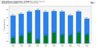
The weekend comes with an increased chance of rain but also heat relief. A weak cold front will push through sometime over the weekend and that will allow temps to fall below normal.
Lightning is a big concern with any storms that form. We've seen a lot of lightning already this year and we also just had a lightning death over the weekend. Please take storms seriously.
~Rain or Shine
I'm Andy Stein

Comments
Post a Comment